De-risk food supply chains in a changing climate
Pinpoint ideal regions for crop diversification and partnerships. This builds a resilient supply chain, efficiently mitigating production risks and managing demand in a changing climate.
Cropin Cloud capability
Assess crop suitability, yield potential, disease pressure and climate risk from country down to county, using satellite data instead of field surveys.
How it works
Compare regions for a crop before you sign growers, open a collection center or plan a new origin.
Cropin Regional Intelligence provides a broad, yet detailed, understanding of agricultural potential and risks across large geographical areas.
It helps you assess crop suitability, yield potential, and predict potential risks like disease pressure or climate impacts for diversification and strategic planning, all driven by data-driven insights.
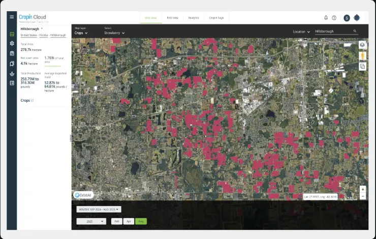
Pinpoint ideal regions for crop diversification and partnerships. This builds a resilient supply chain, efficiently mitigating production risks and managing demand in a changing climate.
Gain unparalleled accuracy powered by Cropin's advanced AI/ML models and proprietary crop knowledge grid for confident data-driven decision-making.
Our parallel processing models rapidly process massive datasets, enabling swift scaling for new crops, seasons, and regions, including remote areas, to quickly identify prime growth markets.
Identify alternative regions with potential to grow specific crops in the future, enabling diversified sourcing strategies and strengthening brand resilience.
Satellite imagery makes the entire assessment process non-invasive with no need for disruptive on-the-ground assessments.
This highly scalable solution delivers accurate and precise agricultural insights across diverse regions and crops, from broad regional overviews to specific areas.
Get agri-intelligence across historical data, near real-time monitoring and in-season forecasting, and long-term forecasts (5-10 years) to drive comprehensive expansion strategies.
Utilize our extensive proprietary crop knowledge grid for accurate and cost-effective identification of various crops across vast areas.
Use Cropin's DEWS (Disease Early Warning System) and comprehensive climate risk analysis to implement proactive risk mitigation efforts, safeguarding future harvests.
Use AI insights to strategically plan your season by factoring in local climate trends and production risks, leading to more resilient and profitable outcomes.
Precisely identify high-yield, low-risk regions that align with demand, allowing you to expand your sourcing smartly and strategically.
Get early production estimates and harvest alerts to optimize your procurement timing, ensuring a stable and efficient supply.
Align storage capacity and contracts effectively by integrating with production forecasts and harvest timing for smoother logistics.
TRUSTED ACROSS GLOBAL FOOD & AGRICULTURE
CUSTOMER IMPACT




Rainforest Alliance is using our AI-powered risk mitigation & crop protection solution to identify cacao plants, predict yields, and...
Read the story Case studyOne of the leading brewing companies in the world partnered with Cropin to streamline their material sourcing of sorghum,...
Read the story Case studyOne of the largest tea corporations based out of India producing 10 million kilograms of tea annually partnered with...
Read the storyCropin Regional Intelligence is a data-driven solution that provides comprehensive insights into agricultural potential, crop suitability, yield forecasts, and climate or disease risks across large geographic regions, from country to county levels, helping businesses make informed strategic decisions.
By analyzing weather patterns, soil data, satellite imagery, historical yields, and other datasets, Cropin identifies high-risk areas and provides early warnings for diseases and climate-related threats. This allows proactive measures to safeguard crops and supply chains.
Yes. Cropin Regional Intelligence pinpoints ideal regions for different crops, enabling diversification, identifying potential new markets, and building resilient, future-ready food supply chains.
Insights are powered by advanced AI/ML models and Cropin’s proprietary crop knowledge grid, ensuring high accuracy across multiple regions, crops, and time horizons, including historical, near real-time, in-season, and long-term forecasts.
No. The solution uses satellite imagery and remote sensing, making it completely contact-free while still providing precise and actionable agricultural insights.
By providing early production estimates, harvest alerts, and risk forecasts, the solution helps optimize sourcing, forecast demand, and align warehouse or cold storage capacities with expected yields, ensuring smooth and efficient logistics operations.