


Transforming the agricultural sector with digital technology that is accessible and beneficial to every farmer
Data-driven insights derived from ground and satellite-based intelligence enable a scientific method of cultivation that is beyond the vagaries of nature. But to make sustainable and scientific agriculture a success, it needs to touch the most important link in the chain – the humble farmer.
Agriculture technology has helped farmers in developed countries improve productivity and enhance the quality of their produce. However, its impact in developing countries is nascent because of the inherent challenges of such economies. Aspects such as fragmented landholdings and lack of farmer awareness make it difficult for smart agriculture to penetrate into such countries. It is why the government and advisory bodies in developing countries are increasingly relying on data-driven intelligence to enhance farmer livelihoods and encourage sustainable agriculture that is both reliable and more productive.
Digitisation of Farmers
Massive advancements and opportunities for agriculture technology have changed the way we cultivate and consume food. Digitisation of farmers in developing countries is a herculean task, but the government and developmental agencies are on a mission to educate farmers about the need to move away from traditional agriculture and adopt a more scientific method of cultivation.
- Digital tracking of day-to-day farming activities
- Crop health analysis
- Timely weather updates and alerts
- Empowering farmers with the latest agronomic news
- Scientifically choosing the right seed varieties for higher productivity
Reliable and Scientific Crop Cutting Experiments for Better Yield Forecast
Traditionally crop cutting experiments (CCE) have relied on manual methods of data collection and analysis that are not just laborious but far from accurate. Using CropIn’s deep-learning solution SmartRisk® has helped governments and agricultural bodies conduct accurate CCEs on a large-scale level, saving time and resources.
- Identification of crop stages and crop detection at a regional level
- Marking accurate CCE points at a plot/farm level
- Health and growth analysis
- Accurate crop yield forecasts
- Real-time insights provide improved visibility throughout cultivation stages
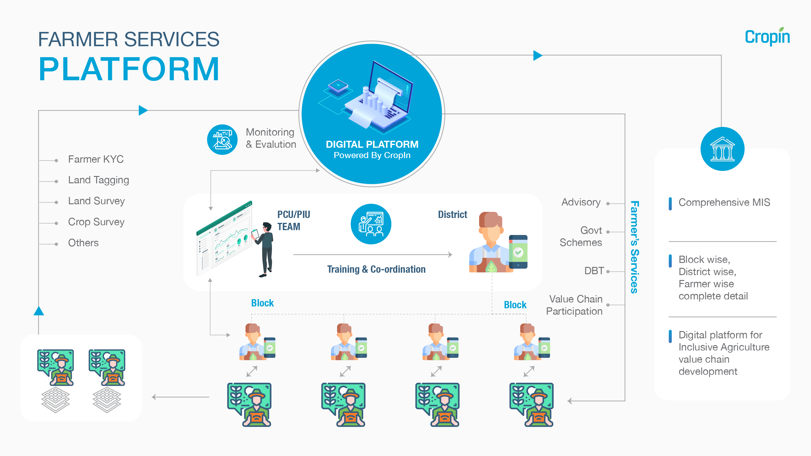
Implementation of Government Schemes at a Village and Regional Level
Unlike developed countries that are characterised by large fields and organised agriculture, adopting digital agriculture in developing countries is fraught with challenges. Smaller fragmented landholdings make scientific cultivation a challenging ordeal logistically. This also affects the impact of government-sponsored developmental schemes and programs that sometimes do not reach the farmers. Putting every farmer on the digital map ensures that there is end-to-end traceability, not just for the crops but also for the government schemes, so they benefit the right people. This, in turn, also promotes sustainable livelihoods for smallholder and marginalised farmers.
- Real-time monitoring of government programs at a regional level
- Satellite-based Crop health detection and health monitoring
- Improving farmer linkages within the ecosystem
- End-to-end traceability of farmer produce
- Using data to design forward-thinking schemes and initiatives for smarter cultivation
Generating Awareness Among Farmers About Sustainable and Climate-Smart Agriculture
Large-scale digitisation improves the efficacy of government initiatives generating an impact throughout the agricultural value chain. However, the greatest need of the hour is to empower farmers with timely intelligence about smarter, more sustainable cultivation methods that maximise output . Additionally, showcasing the impact of scientific cultivation at the field level through agriculture technology helps win farmer trust making smart farming a worldwide movement.
- Crop health analysis
- Real-time alerts on diseases or pest attacks
- Timely weather updates and alerts
- Rule-based weather advisory
- Improving farmer incomes
Using Technology to Pave the Way Towards Prosperity
CropIn’s collaboration with government bodies across geographies has digitally-enabled several thousands of smallholder farms in developing nations. The digitisation of farm activities has facilitated them to increase their yields sustainably and consequently earn a better margin on the sale of their produce. CropIn’s platform also empowers government entities to remotely monitor the progress of the farmers and to design and implement schemes or programs that can further enhance farmer livelihoods.
- Partnering with INCAJU , an initiative of the government of Mozambique and Technoserve, an international non-profit developmental organization, CropIn’s solutions digitised over 100,000 cashew farmers across the country as part of project Mozacaju. Through CropIn, the farmers also received weather-based advisory to promote climate smart agriculture.
- For National Food Security Mission (NFSM), a central-government scheme in India, CropIn teamed up with Agricultural Technology Management Agency (ATMA) in Jalna district, Maharashtra to enhance farm monitoring for export certification, transparency, and accountability
- Working together with the Department of Agriculture (DoA) in the Indian’s stage of Karnataka, CropIn’s SmartFarm was able to impact farmer profitability by enabling them to adapt to climate change. The farm management solution also helped the government to provide incentives to the farmer plotwise, acreage-wise and cropwise.
- In association with the Punjab’s Department of Horticulture and the Punjab State Seed Certification Authority, CropIn provides a traceability solution for PAGREXCO-produced potato seeds. CropIn’s agriculture technology also streamlines the seed certification process to facilitate total visibility and transparency across all processes and stages in seed production.
- CropIn’s partnership with the Government of India and World Bank in a public-private project is enabling 8,000+ Indian farmers to digitally achieve climate-resilient farming across 1650+ hectares of farmland
Explore how CropIn’s solutions can boost your initiatives. Contact us today


